With a total area exceeding 50,000 square miles, Nicaragua (República de Nicaragua) is the largest of all the countries in the Central American isthmus. It borders to Honduras to the north and Costa Rica in the south, and has 450 km of Caribbean coastline and 305 km of coast towards the Pacific Ocean.

nicaragua
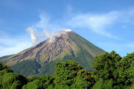
In the 21st century, Nicaragua has rose to become a popular tourist destination, especially among visitors looking for something a bit more rough and unpolished than the neighbouring Costa Rica. There is for instance a band of active volcanoes to explore, stretching from north to south along the Pacific side of the country. Nicaragua is one of few countries where volcano boarding on active volcanoes isn’t just allowed but embraced and arranged by several different tour operators. The most popular slope for this activity – which involves hiking up the volcano slope and then sliding down at a breath-taking pace on a thin plywood or metal board – is Cerro Negro near the city of Leon.
Nearly one fifth of Nicaragua is designated as national parks, nature reserves, biological reserves or otherwise protected areas. This includes the Bosawás Biosphere Reserve in northern Nicaragua, designed as UNESCO biosphere in 1997. Bosawás is the second largest rainforest in the Western Hemisphere; only the Amazon in Brazil is larger. Bosawás overlaps the traditional homelands of two of Nicaragua’s indigenous peoples: the Sumos and the Miskitos.
Short facts about Nicaragua
| Name | República de Nicaragua
(The Republic of Nicaragua) |
| Motto | En Dios confiamos
(In God we trust) |
| Anthem | Salve a ti, Nicaragua
(Hail to Thee, Nicaragua) |
| Official language | Spanish |
| Area | 130,375 square kilometres
(50,338 square miles) |
| Population | 6,2 million (2012 census) |
| Capital | Managua |
| Currency | Córdoba (NIO) |
| Time zone | UTC -6 |
| Calling code | (+) 505 |
| Traffic | Drives on the right |
| Internet TLD | .ni |
Notable cities, villages etc
| Managua |
| León |
| Granada |
| Rivas |
| San Juan del Sur |
| Masaya |
| Estelí |
| Chinandega |
| Jinotega |
| Matagalpa |
| Ciudad Sandino |
| Bluefields |
| Corinto |
Geography
Nicaragua is typically divided into three geographical zones: the Pacific lowlands, the northern-central highlands and the Caribbean lowlands.
 A majority of the population lives in the Pacific lowland, and this is where you find cities such as Managua, Granada, Masaya, León and Rivas. The pacific lowland is fertile and an important source of agricultural produce, with the soil being enriched by ash from the many volcanoes that runs from south to north. The Pacific side of Nicaragua is also home to Central America’s two largest freshwater lakes: Lake Nicaragua (Cocibolca) and Lake Managua. Lake Nicaragua is the 9th largest lake in the Americas, just a tad smaller than Lake Titicaca.
The Northern-central highlands of Nicaragua are largely forested, but this part of the nation is also an important agricultural region where highland crops such as tobacco and shade-grown coffee is grown. Cattle raising and gold extraction are two other major economic activities here. During recent years, Northern-central Nicaragua has become a hotspot for eco-tourism and sustainable-farming tourism.
The Caribbean lowlands of Nicaragua occupies a large part of the nation’s territory, but is sparsely populated and has a high degree of autonomy from Managua. The soil is usually leached and not very fertile, except for areas along natural levees and narrow floodplains. There are many rivers and streams here, coming from the central highlands and seeking the Caribbean Sea. The coast is characterized by bays, lagoons, salt marshes and pale sandy beaches.
Big Corn Island and Little Corn Island – two islands located off the Caribbean coast of mainland Nicaragua – are important tourist destinations, with daily flights available from Managua.
Climate
Pacific lowlands
The Pacific lowlands of Nicaragua are known as tierra caliente – the hot land. Below 2,000 ft (approximately 600 meters) above sea level, the temperature stays high throughout the year, although the dry season is even hotter than the rainy season. The dry season typically starts in November and lasts until May, with the temperature increasing as the dry seasons progresses. Top day temperatures exceeding 35 degrees C are not uncommon from March and onwards, but the temperature usually drops down to circa 25 degrees C at night.
During the rainy season, it is rare for the rains to fall throughout an entire day. Instead, you can expect the mornings and forenoons to be sunny or partly cloudy, and rainfall to start in the afternoon or at night. When it rains, thunderstorms are common.
Northern-central highlands
Northern-central Nicaragua is characterized by mountains and rivers. Elevations of 2,000 ft (circa 600 m) or more make up Nicaragua’s tierra templada – the temperate land. Throughout the year, temperatures tend to stay below 27 degrees C. Compared to the Pacific lowlands, the rainy season is both longer and wetter in the Northern highlands.
Caribbean lowlands
The Caribbean lowlands are largely covered in rainforest, but there are also large tracts of pine and palm savannah regions. The Caribbean lowlands experiences both high temperatures and high humidity, and is the part of Nicaragua that gets the most rainfall – between 2,500 and 6,500 mm annually on average. Unlike western Nicaragua, eastern Nicaragua doesn’t have any protection from the moisture-laden Atlantic trade winds.
During the rainy season, heavy flooding is common in eastern Nicaragua, both along the upper and middle reaches of the major rivers, and near the coast where floodplains are basically turned into a part of the ocean.
Compared to western Nicaragua, the Caribbean side is also less sheltered from Atlantic tropical storms and hurricanes. The risk of hurricanes is at its greatest here from July throughout October. Even when Nicaragua isn’t directly hit by a hurricane, a hurricane being in the vicinity of Nicaragua can cause major downpours.